- Towada (Aomori)
-
Towada-shi
十和田市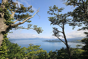
Geographische Lage in Japan 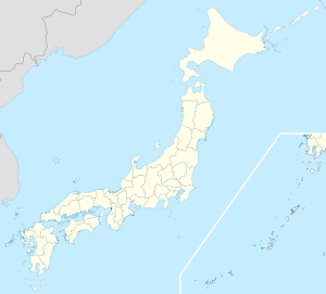

Region: Tōhoku Präfektur: Aomori Koordinaten: 40° 37′ N, 141° 12′ O40.612713888889141.20591388889Koordinaten: 40° 36′ 46″ N, 141° 12′ 21″ O Basisdaten Fläche: 725,67 km² Einwohner: 65.770
(1. Oktober 2011)Bevölkerungsdichte: 91 Einwohner je km² Gemeindeschlüssel: 02206-3 Symbole Baum: Japanische Rotkiefer Blume: Azalee Rathaus Adresse: Towada City Hall
12-6-1, Nishi
Towada-shi
Aomori 034-8615Webadresse: http://www.net.pref.aomori.jp/city/towada/index.html Lage Towadas in der Präfektur Aomori 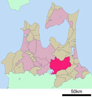
Towada (jap. 十和田市, -shi) ist eine Stadt in der Präfektur Aomori auf Honshū, der Hauptinsel von Japan.
Inhaltsverzeichnis
Geographie
Towada liegt südöstlich von Aomori und nordwestlich von Hachinohe.
Geschichte
Am 1. Februar 1955 schlossen sich die Machi Sambongi (三本木町, -machi) und die Mura Fujisaka (藤坂村, -mura) und Ōfukanai (大深内村, -mura) im Kamikita-gun (上北郡) zur Shi Sambongi (三本木市, -shi) zusammen. Am 1. März desselben Jahres wurde das Mura Shiwa (四和村, -mura) eingemeindet. Am 10. Oktober 1956 erfolgte die Umbenennung zu Towada nach dem nahe gelegenen gleichnamigen See. Am 1. Januar 2005 erfolgte der Zusammenschluss mit dem Machi Towadako (十和田湖町, -machi).
Sehenswürdigkeiten
- Towada-See
- Oirase
- Tsuta-Onsen (Heiße Quelle)
Verkehr
- Straße:
- Tōhoku-Autobahn
- Nationalstraße 4
- Nationalstraßen 45, 102, 103, 394
- Zug:
- Towada-Kankō-Dentetsu-Linie
Angrenzende Städte und Gemeinden
Weblinks
 Commons: Towada – Sammlung von Bildern, Videos und Audiodateien
 Gemeinden und Landkreise in der Präfektur Aomori
Kreisfreie Städte (shi): Aomori (Verwaltungssitz) | Goshogawara | Hachinohe | Hirakawa | Hirosaki | Kuroishi | Misawa | Mutsu | Towada | Tsugaru
Higashitsugaru-gun: Hiranai | Imabetsu | Sotogahama | Yomogita | Kamikita-gun: Noheji | Oirase | Rokkasho | Rokunohe | Shichinohe | Tōhoku | Yokohama | Kitatsugaru-gun: Itayanagi | Nakadomari | Tsuruta | Minamitsugaru-gun: Fujisaki | Inakadate | Ōwani | Nakatsugaru-gun: Nishimeya | Nishitsugaru-gun: Ajigasawa | Fukaura | Sannohe-gun: Gonohe | Hashikami | Nambu | Sannohe | Shingō | Takko | Shimokita-gun: Higashidōri | Kazamaura | Ōma | Sai
Wikimedia Foundation.
Schlagen Sie auch in anderen Wörterbüchern nach:
Towada, Aomori — nihongo|Towada|十和田市|Towada shi is a city located in Aomori, Japan.As of January 1, 2005 with the merger of the town of Towadako the city has an estimated population of 69,238 and a density of 101 persons per km². The total area is 688.6 km². The… … Wikipedia
Towada — ist der Name einer japanische Stadt, siehe Towada (Aomori) eines Vulkans auf Honshu, siehe Towada (Vulkan) eines Sees auf diesem Vulkan, siehe Towada See Diese Seite ist eine Begriffsklärung z … Deutsch Wikipedia
Towada Kankō Electric Railway — The Towada Kanko Electric Railway (十和田観光電鉄 Towada Kankō Dentetsu) is a company that operates the Towada Kanko Electric Railway Line, which connects Misawa Station in the city of Misawa and Towada shi Station in the city of Towada, Aomori… … Wikipedia
Towada Kankō Electric Railway Line — The Towada Kanko Electric Railway Line (十和田観光電鉄線 Towada Kankō Dentetsu sen) connects Misawa Station in the city of Misawa and Towada shi Station in the city of Towada, Aomori Prefecture, Japan. It is operated by the Towada Kanko Electric… … Wikipedia
Towada (Vulkan) — Towada Höhe 1.159 m … Deutsch Wikipedia
Towada-See — Daten Koordinaten … Deutsch Wikipedia
Aomori — shi 青森市 Geographische Lage in Japan … Deutsch Wikipedia
Aomori Broadcasting Corporation — (RAB, 青森放送株式会社, Aomori Hōsō Kabushiki Gaisha ) is a television and radio broadcaster in Aomori, Japan. It is affiliated with Japan Radio Network (JRN), National Radio Network (NRN), Nippon News Network (NNN) and Nippon Television Network System… … Wikipedia
Aomori Station — ja stalink|Akita, ja stalink|Yamagata, and ja stalink|Niigata) *Tsugaru Kaikyō Line (for ja stalink|Kanita, ja stalink|Minmaya, ja stalink|Hakodate, and ja stalink|Sapporo) Limited express trains The following Limited express services stop at… … Wikipedia
Towada-ko — Dieser Artikel behandelt den Towada See (Towada ko). Für die gleichnamige Stadt siehe Towadako (Aomori). Landsat Aufnahme des Sees Der Towada See (jap. 十和田湖?/i, Towada ko) ist der größte … Deutsch Wikipedia
Towada (Aomori)


18+
© Academic, 2000-2024
- Kontaktieren Sie uns: Unterstützung, Werbung
Wörterbücher Export, schritte mit PHP, Joomla, Drupal, WordPress, MODx.