- Burke County (North Carolina)
-
Verwaltung US-Bundesstaat: North Carolina Verwaltungssitz: Morganton Adresse des
Verwaltungssitzes:County Government Building
200 Avery Avenue
Morganton, NC 28655-3103Gründung: 1777 Gebildet aus: Rowan County Vorwahl: 001 828 Demographie Einwohner: 89.148 (2000) Bevölkerungsdichte: 67,9 Einwohner/km² Geographie Fläche gesamt: 1.334 km² Wasserfläche: 21 km² Karte 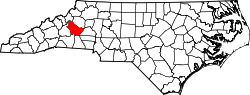
Website: www.co.burke.nc.us Burke County[2] ist ein County im Bundesstaat North Carolina der Vereinigten Staaten von Amerika. Der Verwaltungssitz (County Seat) ist Morganton am Catawba River, das nach Daniel Morgan benannt wurde, einem General im Amerikanischen Unabhängigkeitskrieg.
Inhaltsverzeichnis
Geografie
Das County liegt im Westen von North Carolina, ist im Nordwesten etwa 35 km von Tennessee, im Süden etwa 50 km von South Carolina entfernt und hat eine Fläche von 1334 Quadratkilometern, wovon 21 Quadratkilometer Wasserfläche sind. Es grenzt im Uhrzeigersinn an folgende Countys: Caldwell County, Catawba County, Cleveland County, Rutherford County, McDowell County und Avery County.
Burke County ist in 13 Townships aufgeteilt: Drexel, Icard, Jonas Ridge, Linville, Lovelady, Lower Creek, Lower Fork, Morganton, Quaker Meadows, Silver Creek, Smoky Creek, Upper Creek und Upper Fork.
Geschichte
Burke County wurde 1777 aus Teilen des Rowan County gebildet. Benannt wurde es nach Dr. Thomas Burke, einem Mitglied im Continental Congress und Gouverneur von North Carolina.
Demografische Daten
Historische Einwohnerzahlen Census Einwohner ± in % 1790 8118 — 1800 9929 20 % 1810 11.007 10 % 1820 13.411 20 % 1830 17.888 30 % 1840 15.709 -10 % 1850 7772 -50 % 1860 9237 20 % 1870 9777 6 % 1880 12.809 30 % 1890 14.939 20 % 1900 17.699 20 % 1910 21.408 20 % 1920 23.297 9 % 1930 29.410 30 % 1940 38.615 30 % 1950 45.518 20 % 1960 52.701 20 % 1970 60.364 10 % 1980 72.504 20 % 1990 75.744 4 % 2000 89.148 20 % Vor 1900[3] Nach der Volkszählung im Jahr 2000 lebten im Burke County 89.148 Menschen in 34.528 Haushalten und 24.342 Familien. Die Bevölkerungsdichte beträgt 68 Einwohner pro Quadratkilometer. Ethnisch betrachtet setzt sich die Bevölkerung zusammen aus 86,01 Prozent Weißen, 6,71 Prozent Afroamerikanern, 0,30 Prozent amerikanischen Ureinwohnern, 3,48 Prozent Asiaten, 0,21 Prozent Bewohnern aus dem pazifischen Inselraum und 2,17 Prozent aus anderen ethnischen Gruppen; 1,11 Prozent stammten von zwei oder mehr Ethnien ab. 3,57 Prozent der Bevölkerung waren spanischer oder lateinamerikanischer Abstammung.
Von den 34.528 Haushalten hatten 31,0 Prozent Kinder unter 18 Jahren, die bei ihnen lebten. 54,9 Prozent davon waren verheiratete, zusammenlebende Paare, 11,0 Prozent waren allein erziehende Mütter und 29,5 Prozent waren keine Familien. 25,5 Prozent waren Singlehaushalte und in 9,9 Prozent lebten Menschen mit 65 Jahren oder älter. Die Durchschnittshaushaltsgröße betrug 2,48 und die durchschnittliche Familiengröße war 2,94 Personen.
24,0 Prozent der Bevölkerung waren unter 18 Jahre alt. 8,9 Prozent zwischen 18 und 24 Jahre, 29,6 Prozent zwischen 25 und 44 Jahre, 24,0 Prozent zwischen 45 und 64, und 13,4 Prozent waren 65 Jahre alt oder Älter. Das Durchschnittsalter betrug 37 Jahre. Auf alle weibliche Personen kamen 100,0 männliche Personen. Auf alle Frauen im Alter von 18 Jahren oder darüber kamen 97,7 Männer.
Das jährliche Durchschnittseinkommen eines Haushalts betrug 35.629 $ und das jährliche Durchschnittseinkommen einer Familie betrug 42.114 $. Männer hatten ein durchschnittliches Einkommen von 27.591 $ gegenüber den Frauen mit 21.993 $. Das Prokopfeinkommen betrug 17.397 $. 10,7 Prozent der Bevölkerung und 8,0 Prozent der Familien lebten unterhalb der Armutsgrenze. 13,6 Prozent von ihnen sind Kinder und Jugendliche unter 18 Jahre und 12,5 Prozent sind 65 Jahre oder älter. [6]
Siehe auch
Einzelnachweise
- ↑ Auszug aus dem National Register of Historic Places. Abgerufen am 13. März 2011
- ↑ GNIS-ID: 1008539. Abgerufen am 22. Februar 2011 (englisch).
- ↑ U.S. Census Bureau - Census of Population and Housing. Abgerufen am 15. März 2011
- ↑ Auszug aus Census.gov. Abgerufen am 20. Februar 2011
- ↑ Auszug aus factfinder.census.gov Abgerufen am 20. Februar 2011
- ↑ Burke County, North Carolina, Datenblatt mit den Ergebnissen der Volkszählung im Jahre 2000 bei factfinder.census.gov.

Liste der Countys in North Carolina
Alamance | Alexander | Alleghany | Anson | Ashe | Avery | Beaufort | Bertie | Bladen | Brunswick | Buncombe | Burke | Cabarrus | Caldwell | Camden | Carteret | Caswell | Catawba | Chatham | Cherokee | Chowan | Clay | Cleveland | Columbus | Craven | Cumberland | Currituck | Dare | Davidson | Davie | Duplin | Durham | Edgecombe | Forsyth | Franklin | Gaston | Gates | Graham | Granville | Greene | Guilford | Halifax | Harnett | Haywood | Henderson | Hertford | Hoke | Hyde | Iredell | Jackson | Johnston | Jones | Lee | Lenoir | Lincoln | Macon | Madison | Martin | McDowell | Mecklenburg | Mitchell | Montgomery | Moore | Nash | New Hanover | Northampton | Onslow | Orange | Pamlico | Pasquotank | Pender | Perquimans | Person | Pitt | Polk | Randolph | Richmond | Robeson | Rockingham | Rowan | Rutherford | Sampson | Scotland | Stanly | Stokes | Surry | Swain | Transylvania | Tyrrell | Union | Vance | Wake | Warren | Washington | Watauga | Wayne | Wilkes | Wilson | Yadkin | Yancey
Wikimedia Foundation.
Schlagen Sie auch in anderen Wörterbüchern nach:
Burke County, North Carolina — Infobox U.S. County county = Burke County state = North Carolina map size = 250 founded = 1777 seat = Morganton | area total sq mi =515 area water sq mi =8 area percentage = 1.59% census yr = 2000 pop = 89148 density km2 =68 web = www.co.burke.nc … Wikipedia
National Register of Historic Places listings in Burke County, North Carolina — Map of all coordinates from Google Map of all coordinates from Bing … Wikipedia
Smoky Creek Township, Burke County, North Carolina — Smokey Creek township is a small township in Burke County, North Carolina, close to the Caldwell County line. It is most known for, other than the smokey creek, for Smokey Creek Barbeque and Music Barn, a restaurant with live music and barbeque … Wikipedia
Petersburg, Burke County, North Carolina — Petersburg (formerly, Brittain Store) is an unincorporated community in Burke County, North Carolina. It lies at an elevation of 1175 feet (358 m). It is part of the Hickory ndash;Lenoir ndash;Morganton Metropolitan Statistical… … Wikipedia
McDowell County, North Carolina — McDowell County Courthouse in Marion … Wikipedia
Cleveland County, North Carolina — The west side of the old Cleveland County Courthouse, Shelby … Wikipedia
Caldwell County, North Carolina — Infobox U.S. County county = Caldwell County state = North Carolina map size = 250 founded = 1841 seat = Lenoir | area total sq mi =474 area water sq mi =3 area percentage = 0.57% census yr = 2000 pop = 77415 density km2 =63 web = www.co.caldwell … Wikipedia
Rutherford County, North Carolina — Infobox U.S. County county = Rutherford County state = North Carolina map size = 250 founded = 1779 seat = Rutherfordton | area total sq mi =566 area water sq mi =2 area percentage = 0.31% census yr = 2000 pop = 62899 density km2 =43 web =… … Wikipedia
Lincoln County, North Carolina — Infobox U.S. County county = Lincoln County state = North Carolina map size = 250 founded = 1779 seat = Lincolnton | area total sq mi =307 area water sq mi =8 area percentage = 2.68% census yr = 2000 pop = 63780 density km2 =82 web =… … Wikipedia
Avery County, North Carolina — Infobox U.S. County county = Avery County state = North Carolina map size = 250 founded = 1911 seat = Newland | area total sq mi =247 area water sq mi =0 area percentage = 0.08% census yr = 2000 pop = 17167 density km2 =27 web = www.averycountync … Wikipedia
Burke County (North Carolina)


18+
© Academic, 2000-2024
- Kontaktieren Sie uns: Unterstützung, Werbung
Wörterbücher Export, schritte mit PHP, Joomla, Drupal, WordPress, MODx.