- Haywood County (North Carolina)
-
Verwaltung US-Bundesstaat: North Carolina Verwaltungssitz: Waynesville Adresse des
Verwaltungssitzes:County Courthouse
215 N Main Street
Waynesville, NC 28786-3869Gründung: 1808 Gebildet aus: Buncombe County Vorwahl: 001 828 Demographie Einwohner: 54.033 (2000) Bevölkerungsdichte: 37,7 Einwohner/km² Geographie Fläche gesamt: 1.436 km² Wasserfläche: 2 km² Karte 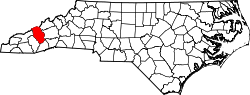
Website: www.gov.co.haywood.nc.us Haywood County[1] ist ein County im Bundesstaat North Carolina der Vereinigten Staaten von Amerika. Im Jahr 2000 hatte das County 54.033 Einwohner und eine Bevölkerungsdichte von 38 Einwohnern pro Quadratkilometer. Der Verwaltungssitz (County Seat) ist Waynesville, das nach General Anthony Wayne benannt wurde.
Inhaltsverzeichnis
Geographie
Das County liegt im Westen von North Carolina, grenzt im Norden an Tennessee, ist im Süden etwa 40 km von Georgia und South Carolina entfernt und hat eine Fläche von 1436 Quadratkilometern, wovon 2 Quadratkilometer Wasserfläche sind. Es grenzt im Uhrzeigersinn an folgende Countys: Madison County, Buncombe County, Transylvania County, Jackson County und Swain County.
Haywood County ist in 15 Townships aufgeteilt: Beaverdam, Bethel, Cataloochee (im Cataloochee Valley), Cecil, Clyde, Crabtree, Cruso, East Fork, Fines Creek, Iron Duff, Ivy Hill, Jonathan Creek, Pigeon, Waynesville und White Oak.
Geschichte
Haywood County wurde 1808 aus Teilen des Buncombe County gebildet. Benannt wurde es nach John Haywood, einem US-Politiker und Finanzminister.
Demografische Daten
Historische Einwohnerzahlen Census Einwohner ± in % 1810 2780 — 1820 4073 50 % 1830 4578 10 % 1840 4975 9 % 1850 7074 40 % 1860 5801 -20 % 1870 7921 40 % 1880 10.271 30 % 1890 13.346 30 % 1900 16.222 20 % 1910 21.020 30 % 1920 23.496 10 % 1930 28.273 20 % 1940 34.804 20 % 1950 37.631 8 % 1960 39.711 6 % 1970 41.710 5 % 1980 46.495 10 % 1990 46.942 1 % 2000 54.033 20 % Vor 1900[2] Nach der Volkszählung im Jahr 2000 lebten im Haywood County 54.033 Menschen. Davon wohnten 961 Personen in Sammelunterkünften, die anderen Einwohner lebten in 23.100 Haushalten und 16.054 Familien. Die Bevölkerungsdichte beträgt 38 Einwohner pro Quadratkilometer. Ethnisch betrachtet setzt sich die Bevölkerung zusammen aus 96,85 Prozent Weißen, 1,27 Prozent Afroamerikanern, 0,49 Prozent Indianern, 0,21 Prozent Asiatischen Amerikanern, 0,04 Prozent Pazifischen Insulanern und 0,44 Prozent aus anderen ethnischen Gruppen; 0,71 Prozent stammten von zwei oder mehr Ethnien ab. 1,41 Prozent der Bevölkerung waren Hispanics oder Latinos.
Von den 23.100 Haushalten hatten 26,2 Prozent Kinder unter 18 Jahren, die bei ihnen lebten. 56,7 Prozent davon waren verheiratete, zusammenlebende Paare, 9,5 Prozent waren allein erziehende Mütter und 30,5 Prozent waren keine Familien. 26,7 Prozent waren Singlehaushalte und in 12,3 Prozent lebten Menschen mit 65 Jahren oder älter. Die Durchschnittshaushaltsgröße betrug 2,30 und die durchschnittliche Familiengröße war 2,76 Personen.
20,8 Prozent der Bevölkerung waren unter 18 Jahre alt. 6,2 Prozent zwischen 18 und 24 Jahre, 26,9 Prozent zwischen 25 und 44 Jahre, 27,1 Prozent zwischen 45 und 64, und 19,0 Prozent waren 65 Jahre alt oder älter. Das Durchschnittsalter betrug 42 Jahre. Auf alle weibliche Personen kamen 92,0 männliche Personen. Auf alle Frauen im Alter ab 18 Jahren kamen 88,7 Männer.
Das jährliche Durchschnittseinkommen eines Haushalts betrug 33.922 US-$ und das jährliche Durchschnittseinkommen einer Familie betrug 40.438 $. Männer hatten ein durchschnittliches Einkommen von 30.731 $, Frauen 21.750 $. Das Prokopfeinkommen betrug 18.554 $. 11,5 Prozent der Bevölkerung und 8,1 Prozent der Familien lebten unterhalb der Armutsgrenze. 17,4 Prozent von ihnen sind Kinder und Jugendliche unter 18 Jahre und 10,3 Prozent sind 65 Jahre oder älter. [5]
Siehe auch
Einzelnachweise
- ↑ GNIS-ID: 1008561. Abgerufen am 22. Februar 2011 (englisch).
- ↑ U.S. Census Bureau - Census of Population and Housing. Abgerufen am 15. März 2011
- ↑ Auszug aus Census.gov. Abgerufen am 20. Februar 2011
- ↑ Auszug aus factfinder.census.gov Abgerufen am 20. Februar 2011
- ↑ Haywood County, North Carolina, Datenblatt mit den Ergebnissen der Volkszählung im Jahre 2000 bei factfinder.census.gov.

Liste der Countys in North Carolina
Alamance | Alexander | Alleghany | Anson | Ashe | Avery | Beaufort | Bertie | Bladen | Brunswick | Buncombe | Burke | Cabarrus | Caldwell | Camden | Carteret | Caswell | Catawba | Chatham | Cherokee | Chowan | Clay | Cleveland | Columbus | Craven | Cumberland | Currituck | Dare | Davidson | Davie | Duplin | Durham | Edgecombe | Forsyth | Franklin | Gaston | Gates | Graham | Granville | Greene | Guilford | Halifax | Harnett | Haywood | Henderson | Hertford | Hoke | Hyde | Iredell | Jackson | Johnston | Jones | Lee | Lenoir | Lincoln | Macon | Madison | Martin | McDowell | Mecklenburg | Mitchell | Montgomery | Moore | Nash | New Hanover | Northampton | Onslow | Orange | Pamlico | Pasquotank | Pender | Perquimans | Person | Pitt | Polk | Randolph | Richmond | Robeson | Rockingham | Rowan | Rutherford | Sampson | Scotland | Stanly | Stokes | Surry | Swain | Transylvania | Tyrrell | Union | Vance | Wake | Warren | Washington | Watauga | Wayne | Wilkes | Wilson | Yadkin | Yancey
Wikimedia Foundation.
Schlagen Sie auch in anderen Wörterbüchern nach:
Haywood County, North Carolina — Infobox U.S. County county = Haywood County state = North Carolina map size = 250 founded = 1808 seat = Waynesville | area total sq mi =555 area water sq mi =1 area percentage = 0.17% census yr = 2000 pop = 54033 density km2 =37.68 web =… … Wikipedia
National Register of Historic Places listings in Haywood County, North Carolina — Map of all coordinates from Google Map of all coordinates from Bing … Wikipedia
Canton Middle School (Haywood County, North Carolina) — Canton Middle School (CMS) is located in Canton, Haywood County, North Carolina. Before CMS became a middle school it was a high school called Canton High School. Canton Middle School mascot is a bear and the CMS school colors are red and black.… … Wikipedia
Jackson County, North Carolina — Old Jackson County Courthouse in downtown Sylva … Wikipedia
Buncombe County, North Carolina — Infobox U.S. County county=Buncombe County state=North Carolina map size=250 founded=1791 seat=Asheville area total sq mi=660 area land sq mi=656 area water sq mi=4 area percentage=0.58% census yr=2006 pop=222174 density km2=121… … Wikipedia
Swain County, North Carolina — Infobox U.S. County county = Swain County state = North Carolina map size = 250 founded = 1871 seat = Bryson City | area total sq mi =541 area water sq mi =13 area percentage = 2.32% census yr = 2000 pop = 12968 density km2 =9 web =… … Wikipedia
Madison County, North Carolina — Infobox U.S. County county = Madison County state = North Carolina map size = 250 founded = 1851 seat = Marshall | area total sq mi =452 area water sq mi =2 area percentage = 0.48% census yr = 2000 pop = 19635 density km2 =17 web =… … Wikipedia
Transylvania County, North Carolina — Infobox U.S. County county = Transylvania County state = North Carolina map size = 250 founded = 1861 seat = Brevard | area total sq mi =381 area water sq mi =2 area percentage = 0.57% census yr = 2000 pop = 29334 density km2 =30 web =… … Wikipedia
Chatham County, North Carolina — Chatham County Courthouse in Pittsboro … Wikipedia
Jackson County (North Carolina) — Jackson County Courthouse, gelistet im NRHP mit der Nr. 79001727[1] Verwaltung … Deutsch Wikipedia
Haywood County (North Carolina)

18+
© Academic, 2000-2024
- Kontaktieren Sie uns: Unterstützung, Werbung
Wörterbücher Export, schritte mit PHP, Joomla, Drupal, WordPress, MODx.