- Forsyth County (North Carolina)
-
Verwaltung US-Bundesstaat: North Carolina Verwaltungssitz: Winston-Salem Adresse des
Verwaltungssitzes:County Courthouse
201 N. Chestnut
Winston-Salem, NC 27101-4120Gründung: 1849 Gebildet aus: Stokes County Vorwahl: 001 336 Demographie Einwohner: 306.067 (2000) Bevölkerungsdichte: 288,7 Einwohner/km² Geographie Fläche gesamt: 1.069 km² Wasserfläche: 9 km² Karte 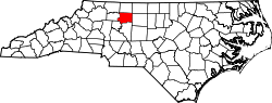
Website: www.co.forsyth.nc.us Forsyth County[1] ist ein County im Bundesstaat North Carolina der Vereinigten Staaten von Amerika. Der Verwaltungssitz (County Seat) ist Winston-Salem, das nach Joseph Winston benannt wurde, einem Major während des Amerikanischen Unabhängigkeitskrieges.
Inhaltsverzeichnis
Geografie
Das County liegt im mittleren Nordwesten, ist im Norden etwa 40 km von Virginia entfernt und hat eine Fläche von 1069 Quadratkilometern, wovon 9 Quadratkilometer Wasserfläche sind. Es grenzt im Uhrzeigersinn an folgende Countys: Stokes County, Guilford County, Davidson County, Davie County, Yadkin County und Surry County.
Forsyth County ist in 14 Townships aufgeteilt: Abbotts Creek, Belews Creek, Bethania, Broadbay, Clemmons, Kernersville, Lewisville, Middle Fork, Old Richmond, Salem Chapel, South Fork, Vienna, Walkertown und Winston-Salem.
Geschichte
Forsyth County wurde 1849 aus Teilen des Stokes County gebildet. Benannt wurde es nach Colonel Benjamin Forsyth, einem Großgrundbesitzer in dieser Gegend, der im Krieg von 1812 getötet wurde.
Demografische Daten
Historische Einwohnerzahlen Census Einwohner ± in % 1850 11.168 — 1860 12.692 10 % 1870 13.050 3 % 1880 18.070 40 % 1890 28.434 60 % 1900 35.261 20 % 1910 47.311 30 % 1920 77.269 60 % 1930 111.681 40 % 1940 126.475 10 % 1950 146.135 20 % 1960 189.428 30 % 1970 214.348 10 % 1980 243.683 10 % 1990 265.878 9 % 2000 306.067 20 % Vor 1900[2] Nach der Volkszählung im Jahr 2000 lebten im Forsyth County 306.067 Menschen. Davon wohnten 9.949 Personen in Sammelunterkünften, die anderen Einwohner lebten in 123.851 Haushalten und 81.741 Familien. Die Bevölkerungsdichte beträgt 289 Einwohner pro Quadratkilometer. Ethnisch betrachtet setzte sich die Bevölkerung zusammen aus 68,47 Prozent Weißen, 25,61 Prozent Afroamerikanern, 0,30 Prozent amerikanischen Ureinwohnern, 1,04 Prozent Asiaten, 0,03 Prozent Bewohnern aus dem pazifischen Inselraum und 3,25 Prozent aus anderen ethnischen Gruppen; 1,30 Prozent stammten von zwei oder mehr Ethnien ab. 6,40 Prozent der Bevölkerung waren spanischer oder lateinamerikanischer Abstammung.
Von den 123.851 Haushalten hatten 30,5 Prozent Kinder unter 18 Jahren, die bei ihnen lebten. 48,9 Prozent davon waren verheiratete, zusammenlebende Paare, 13,5 Prozent waren allein erziehende Mütter und 34,0 Prozent waren keine Familien. 28,9 Prozent waren Singlehaushalte und in 9,3 Prozent lebten Menschen mit 65 Jahren oder älter. Die Durchschnittshaushaltsgröße betrug 2,39 und die durchschnittliche Familiengröße war 2,94 Personen.
23,9 Prozent der Bevölkerung waren unter 18 Jahre alt. 9,6 Prozent zwischen 18 und 24 Jahre, 31,1 Prozent zwischen 25 und 44 Jahre, 22,8 Prozent zwischen 45 und 64, und 12,6 Prozent waren 65 Jahre alt oder Älter. Das Durchschnittsalter betrug 36 Jahre. Auf alle weibliche Personen kamen 91,5 männliche Personen. Auf alle Frauen im Alter von 18 Jahren oder darüber kamen 87,4 Männer.
Das jährliche Durchschnittseinkommen eines Haushalts betrug 42.097 US-$ und das jährliche Durchschnittseinkommen einer Familie betrug 52.032 $. Männer hatten ein durchschnittliches Einkommen von 36.158 $, Frauen 27.319 $. Das Prokopfeinkommen betrug 23.023 $. 11,0 Prozent der Bevölkerung und 7,9 Prozent der Familien lebten unterhalb der Armutsgrenze. Darunter waren 15,1 Prozent der Kinder und Jugendlichen unter 18 Jahren und 9,7 Prozent der Personen ab 65 Jahren. [5]
Größte Städte
- Bethania
- Clemmons
- Kernersville
- Lewisville
- Rural Hall
- Tobaccoville
- Walkertown
- Winston-Salem
Siehe auch
Einzelnachweise
- ↑ GNIS-ID: 1008552. Abgerufen am 22. Februar 2011 (englisch).
- ↑ U.S. Census Bureau - Census of Population and Housing. Abgerufen am 15. März 2011
- ↑ Auszug aus Census.gov. Abgerufen am 20. Februar 2011
- ↑ Auszug aus factfinder.census.gov Abgerufen am 20. Februar 2011
- ↑ Forsyth County, North Carolina, Datenblatt mit den Ergebnissen der Volkszählung im Jahre 2000 bei factfinder.census.gov.

Liste der Countys in North Carolina
Alamance | Alexander | Alleghany | Anson | Ashe | Avery | Beaufort | Bertie | Bladen | Brunswick | Buncombe | Burke | Cabarrus | Caldwell | Camden | Carteret | Caswell | Catawba | Chatham | Cherokee | Chowan | Clay | Cleveland | Columbus | Craven | Cumberland | Currituck | Dare | Davidson | Davie | Duplin | Durham | Edgecombe | Forsyth | Franklin | Gaston | Gates | Graham | Granville | Greene | Guilford | Halifax | Harnett | Haywood | Henderson | Hertford | Hoke | Hyde | Iredell | Jackson | Johnston | Jones | Lee | Lenoir | Lincoln | Macon | Madison | Martin | McDowell | Mecklenburg | Mitchell | Montgomery | Moore | Nash | New Hanover | Northampton | Onslow | Orange | Pamlico | Pasquotank | Pender | Perquimans | Person | Pitt | Polk | Randolph | Richmond | Robeson | Rockingham | Rowan | Rutherford | Sampson | Scotland | Stanly | Stokes | Surry | Swain | Transylvania | Tyrrell | Union | Vance | Wake | Warren | Washington | Watauga | Wayne | Wilkes | Wilson | Yadkin | Yancey
Wikimedia Foundation.
Schlagen Sie auch in anderen Wörterbüchern nach:
Forsyth County, North Carolina — Infobox U.S. County county = Forsyth County state = North Carolina map size = 250 founded = 1849 seat = Winston Salem | area total sq mi =413 area land sq mi =410 area water sq mi =3 area percentage = 0.80% census yr = 2006 pop = 332,355 density… … Wikipedia
National Register of Historic Places listings in Forsyth County, North Carolina — Map of all coordinates from Google Map of all coordinates from Bing … Wikipedia
Old Richmond Township, Forsyth County, North Carolina — Location of Old Richmond Township in Forsyth County, N.C. Old Richmond Township is one of fourteen townships in Forsyth County, North Carolina, USA. The township had a population of 5,165 according to the 2000 census. Geographically, Old Richmond … Wikipedia
Old Town Township, Forsyth County, North Carolina — Location of Old Town Township in Forsyth County, N.C. Old Town Township is one of fourteen townships in Forsyth County, North Carolina, USA. The township had a population of 176 according to the 2000 census. Geographically, Old Town Township… … Wikipedia
Clemmonsville Township, Forsyth County, North Carolina — Location of Clemmonsville Township in Forsyth County, N.C. Clemmonsville Township is one of fourteen townships in Forsyth County, North Carolina, USA. The township had a population of 13,123 according to the 2000 census. There is no Clemmonsville … Wikipedia
Middle Fork Township, Forsyth County, North Carolina — Location of Middle Fork Township in Forsyth County, N.C. Middle Fork Township is one of fourteen townships in Forsyth County, North Carolina, USA. The township had a population of 6,779 according to the 2000 census. Geographically, Middle Fork… … Wikipedia
Old Town, Forsyth County, North Carolina — Old Town (or Oldtown) is a former unincorporated community in North Carolina, which was annexed by Winston Salem. It was located near Bethania, Tobaccoville, and Pfafftown along NC 67. Coordinates: 36°09′58″N 80°20′01″W … Wikipedia
Abbotts Creek Township, Forsyth County, North Carolina — Abbotts Creek Township is one of fourteen townships in Forsyth County, North Carolina, USA. The township had a population of 12,869 according to the 2000 census.Geographically, Abbotts Creek Township occupies 31.61 square miles in southeastern… … Wikipedia
Winston Township, Forsyth County, North Carolina — Winston Township is one of fourteen townships in Forsyth County, North Carolina, United States. The township had a population of 185,776 according to the 2000 census.Geographically, Winston Township occupies 109.63 square miles in central Forsyth … Wikipedia
Bethania Township, Forsyth County, North Carolina — Bethania Township is one of fourteen townships in Forsyth County, North Carolina, USA. The township had a population of 9,543 according to the 2000 census.Geographically, Bethania Township occupies 25.23 square miles in northern Forsyth County.… … Wikipedia
Forsyth County (North Carolina)

18+
© Academic, 2000-2024
- Kontaktieren Sie uns: Unterstützung, Werbung
Wörterbücher Export, schritte mit PHP, Joomla, Drupal, WordPress, MODx.