- Dewey County (South Dakota)
-
Verwaltung US-Bundesstaat: South Dakota Verwaltungssitz: Timber Lake Gründung: 1883 Demographie Einwohner: 5972 (2000) Bevölkerungsdichte: 1 Einwohner/km² Geographie Fläche gesamt: 6.334 km² Wasserfläche: 370 km² Karte 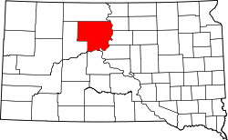
Dewey County[1] ist ein County im Norden des US-Bundesstaates South Dakota, Vereinigte Staaten.
Inhaltsverzeichnis
Geographie
Das County hat eine Fläche von 6.334 Quadratkilometern; davon sind 370 Quadratkilometer (2,07 Prozent) Wasserflächen. Fast die gesamte Fläche gehört zum Cheyenne-River-Reservat, der nördliche Teil gehört zum Standing-Rock-Reservat. Damit ist Dewey County einer von fünf Bezirken in South Dakota, die komplett in Indianerreservaten liegen. Das County teilt sich in zwei unorganisierte Territorien: Norht Dewey und South Dewey.
Bevölkerungsentwicklung
Historische Einwohnerzahlen Census Einwohner ± in % 1910 1145 — 1920 4802 300 % 1930 6476 30 % 1940 5709 -10 % 1950 4916 -10 % 1960 5257 7 % 1970 5170 -2 % 1980 5366 4 % 1990 5523 3 % 2000 5972 8 % 2010 5301 -10 % 1900–1990[2] 2000[3]
Städte und Gemeinden
Städte (cities)
- Eagle Butte
- Timber Lake
Gemeinden (towns)
- Isabel
- Green Grass
- La Plant
- North Eagle Butte
- Whitehorse
Einzelnachweise
- ↑ Dewey County im Geographic Names Information System des United States Geological Survey. Abgerufen am 22. Februar 2011
- ↑ Auszug aus Census.gov. Abgerufen am 28. Februar 2011
- ↑ Auszug aus factfinder.census.gov Abgerufen am 28. Februar 2011

Liste der Countys in South Dakota
Aurora | Beadle | Bennett | Bon Homme | Brookings | Brown | Brule | Buffalo | Butte | Campbell | Charles Mix | Clark | Clay | Codington | Corson | Custer | Davison | Day | Deuel | Dewey | Douglas | Edmunds | Fall River | Faulk | Grant | Gregory | Haakon | Hamlin | Hand | Hanson | Harding | Hughes | Hutchinson | Hyde | Jackson | Jerauld | Jones | Kingsbury | Lake | Lawrence | Lincoln | Lyman | Marshall | McCook | McPherson | Meade | Mellette | Miner | Minnehaha | Moody | Pennington | Perkins | Potter | Roberts | Sanborn | Shannon | Spink | Stanley | Sully | Todd | Tripp | Turner | Union | Walworth | Yankton | Ziebach
Wikimedia Foundation.
Schlagen Sie auch in anderen Wörterbüchern nach:
Dewey County, South Dakota — Location in the state of South Dakota … Wikipedia
National Register of Historic Places listings in Dewey County, South Dakota — Location of Dewey County in South Dakota This is a list of the National Register of Historic Places listings in Dewey County, South Dakota. This is intended to be a complete list of the properties and districts on the National Register of… … Wikipedia
Corson County, South Dakota — Corson County Courthouse in McIntosh, South Dakota in 1993. This building was destroyed by fire on April 10, 2006 … Wikipedia
Minnehaha County (South Dakota) — Verwaltung US Bundesstaat: South Dakota Verwaltungssitz: Sioux Falls Adresse des Verwaltungssitzes: Gründung … Deutsch Wikipedia
Ziebach County (South Dakota) — Verwaltung US Bundesstaat: South Dakota Verwaltungssitz: Dupree Adresse des Verwaltungssitzes: Gründung … Deutsch Wikipedia
Ziebach County, South Dakota — Infobox U.S. County county = Ziebach County state = South Dakota founded year = founded date = seat wl = Dupree largest city wl = Dupree area total sq mi = 1971 area total km2 = 5105 area land sq mi = 1962 area land km2 = 5082 area water sq mi =… … Wikipedia
Walworth County, South Dakota — Infobox U.S. County county = Walworth County state = South Dakota founded year = founded date = seat wl = Selby largest city wl = area total sq mi = 744 area total km2 = 1928 area land sq mi = 708 area land km2 = 1833 area water sq mi = 36 area… … Wikipedia
Sully County, South Dakota — Infobox U.S. County county = Sully County state = South Dakota founded year = founded date = seat wl = Onida largest city wl = area total sq mi = 1070 area total km2 = 2772 area land sq mi =1007 area land km2 = 2608 area water sq mi = 63 area… … Wikipedia
Stanley County, South Dakota — Infobox U.S. County county = Stanley County state = South Dakota founded year = founded date = seat wl = Fort Pierre largest city wl = area total sq mi = 1517 area total km2 = 3929 area land sq mi = 1443 area land km2 = 3738 area water sq mi = 74 … Wikipedia
Potter County, South Dakota — Infobox U.S. County county = Potter County state = South Dakota founded year = founded date = seat wl = Gettysburg largest city wl = area total sq mi = 898 area total km2 = 2327 area land sq mi =866 area land km2 = 2244 area water sq mi = 32 area … Wikipedia
Dewey County (South Dakota)

18+
© Academic, 2000-2024
- Kontaktieren Sie uns: Unterstützung, Werbung
Wörterbücher Export, schritte mit PHP, Joomla, Drupal, WordPress, MODx.