- Lingayén
-
Municipality of Lingayén Lage von Lingayén in der Provinz Pangasinán 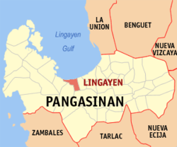
Basisdaten Bezirk: Ilocos-Region Provinz: Pangasinán Barangays: 32 Distrikt: 2. Distrikt von Pangasinán PSGC: 015522000 Einkommensklasse: 1. Einkommensklasse Haushalte: 16.467 Zensus 1. Mai 2000Einwohnerzahl: 95.773 Zensus 1. August 2007Koordinaten: 16° 1′ N, 120° 14′ O16.016666666667120.23333333333Koordinaten: 16° 1′ N, 120° 14′ O Postleitzahl: 2401 Vorwahl: +63 75 Geographische Lage auf den Philippinen 

Lingayén Lingayén ist eine Stadtgemeinde in der philippinischen Provinz Pangasinán und der Verwaltungssitz der Provinz. Im Jahre 2000 zählte Lingayén 88.891 Einwohner und 16.467 Haushalte. Der Golf von Lingayén ist nach der Gemeinde, welche direkt an der Küste liegt, benannt. Die Stadtgemeinde ist auch der Geburtsort des ehemaligen philippinischen Präsidenten Fidel V. Ramos.
Lingayén ist aufgeteilt in folgende 32 Baranggays:
- Aliwekwek
- Baay
- Balangobong
- Balococ
- Bantayan
- Basing
- Capandanan
- Domalandan Center
- Domalandan East
- Domalandan West
- Dorongan
- Dulag
- Estanza
- Lasip
- Libsong East
- Libsong West
- Malawa
- Malimpuec
- Maniboc
- Matalava
- Naguelguel
- Namolan
- Pangapisan North
- Pangapisan Sur
- Poblacion
- Quibaol
- Rosario
- Sabangan
- Talogtog
- Tonton
- Tumbar
- Wawa
Städte und Stadtgemeinden in der Provinz PangasinánStädte: Alaminos | Dagupan | San Carlos City | Urdaneta
Stadtgemeinden: Agno | Aguilar | Alcala | Anda | Asingan | Balungao | Bani | Basista | Bautista | Bayambang | Binalonan | Binmaley | Bolinao | Bugallon | Burgos | Calasiao | Dasol | Infanta | Labrador | Laoac | Lingayén | Mabini | Malasiqui | Manaoag | Mangaldan | Mangatarem | Mapandan | Natividad | Pozzorubio | Rosales | San Fabian | San Jacinto | San Manuel | San Nicolas | San Quintin | Santa Barbara | Santa Maria | Santo Tomas | Sison | Sual | Tayug | Umingan | Urbiztondo | Villasis
Wikimedia Foundation.
Schlagen Sie auch in anderen Wörterbüchern nach:
Lingayen — can refer to:* Lingayen Gulf, a gulf in the Philippines. * Lingayen, Pangasinan, the capital of Pangasinan province, in the Philippines. * USS Lingayen , a Commencement Bay class escort carrier of the United States Navy … Wikipedia
Lingayen — Lingayen, Meerbusen u. Stadt an der Westküste der Philippineninsel Manila (Südostasien) … Pierer's Universal-Lexikon
Lingayen — Municipality of Lingayén Lage von Lingayen in der Provinz Pangasinán Basisdaten Bezirk: Ilocos Region … Deutsch Wikipedia
Lingayén — Para il golfo, véase Golfo de Lingayén. Lingayén es la cabecera de la provincia filipina de Pangasinán. Según el censo del 2000, tiene 88.891 habitantes en 16.467 casas. Aquí se sitúa la popular Playa de Lingayén. Barangay Lingayén se divide… … Wikipedia Español
Lingayen — Original name in latin Lingayen Name in other language Lingayen State code PH Continent/City Asia/Manila longitude 16.02182 latitude 120.23194 altitude 9 Population 56580 Date 2011 07 31 … Cities with a population over 1000 database
Lingayen — 16° 01′ 00″ N 120° 13′ 59″ E / 16.0167, 120.233 Lingayen est une municip … Wikipédia en Français
Lingayen, Pangasinan — Infobox Philippine municipality infoboxtitle = Municipality of Lingayen, Pangasinan sealfile = Lingayen Pangasinan.png region = Ilocos Region (Region I) province = Pangasinan pop2007 = 95,773 barangays = 32 districts = 2nd District, Pangasinan… … Wikipedia
Lingayen Gulf — The Lingayen Gulf is an extension of the South China Sea on Luzon in the Philippines stretching convert|56|km|mi|0. It is framed by the provinces of Pangasinan and La Union and sits between the Zambales Mountains and the Cordillera Central. The… … Wikipedia
Lingayen Gulf — /ling gah yen / a gulf in the Philippines, on the NW coast of Luzon. * * * Inlet, South China Sea, northwestern coast of Luzon, Philippines. It is 26 mi (42 km) wide at its entrance and 36 mi (56 km) long. It has several islands; on Pangasinan… … Universalium
Lingayen, golfo de — Ensenada situada en el sur del mar de China, en la costa noroeste de Luzón en Filipinas. Tiene 56 km (36 mi) de largo y un ancho, en la entrada, de 42 km (26 mi). Hay en él varias islas; en la provincia de Pangasinan se encuentran Dagupan, el… … Enciclopedia Universal
Lingayén


18+
© Academic, 2000-2024
- Kontaktieren Sie uns: Unterstützung, Werbung
Wörterbücher Export, schritte mit PHP, Joomla, Drupal, WordPress, MODx.