- Clark County (South Dakota)
-
Verwaltung US-Bundesstaat: South Dakota Verwaltungssitz: Clark Gründung: 1873 Demographie Einwohner: 4143 (2000) Bevölkerungsdichte: 1,7 Einwohner/km² Geographie Fläche gesamt: 2.507 km² Wasserfläche: 26 km² Karte 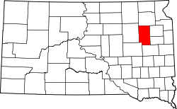
Clark County[1] ist ein Bezirk im Bundesstaat South Dakota der Vereinigten Staaten von Amerika. Es hat 4.143 Einwohner. Der Verwaltungssitz (County Seat) ist Clark.
Inhaltsverzeichnis
Geographie
Das County hat eine Fläche von 2507 Quadratkilometern; davon sind 26 Quadratkilometer (1,02 Prozent) Wasserflächen.
Bevölkerungsentwicklung
Historische Einwohnerzahlen Census Einwohner ± in % 1900 6942 — 1910 10.901 60 % 1920 11.136 2 % 1930 11.022 -1 % 1940 8955 -20 % 1950 8369 -7 % 1960 7134 -10 % 1970 5515 -20 % 1980 4894 -10 % 1990 4403 -10 % 2000 4143 -6 % 2010 3691 -10 % 1900–1990[2] 2000[3]
Städte und Gemeinden
Städte (cities)
- Clark
- Naples
- Willow Lake
Gemeinden (towns)
- Vienna
- Raymond
- Garden City
- Bradley
Gemeindefreie Gebiete
- Elrod
- Crocker
- Carpenter
Townships
Das County ist in 27 Townships eingeteilt: Ash, Blaine, Collins, Cottonwood, Darlington, Day, Eden, Elrod, Fordham, Foxton, Garfield, Hague, Lake, Lincoln, Logan, Maydell, Merton, Mount Pleasant, Pleasant, Raymond, Richland, Rosedale, Spring Valley, Thorp, Warren, Washington und Woodland.
Einzelnachweise
- ↑ Clark County im Geographic Names Information System des United States Geological Survey. Abgerufen am 22. Februar 2011
- ↑ Auszug aus Census.gov. Abgerufen am 28. Februar 2011
- ↑ Auszug aus factfinder.census.gov Abgerufen am 28. Februar 2011

Liste der Countys in South Dakota
Aurora | Beadle | Bennett | Bon Homme | Brookings | Brown | Brule | Buffalo | Butte | Campbell | Charles Mix | Clark | Clay | Codington | Corson | Custer | Davison | Day | Deuel | Dewey | Douglas | Edmunds | Fall River | Faulk | Grant | Gregory | Haakon | Hamlin | Hand | Hanson | Harding | Hughes | Hutchinson | Hyde | Jackson | Jerauld | Jones | Kingsbury | Lake | Lawrence | Lincoln | Lyman | Marshall | McCook | McPherson | Meade | Mellette | Miner | Minnehaha | Moody | Pennington | Perkins | Potter | Roberts | Sanborn | Shannon | Spink | Stanley | Sully | Todd | Tripp | Turner | Union | Walworth | Yankton | Ziebach
Wikimedia Foundation.
Schlagen Sie auch in anderen Wörterbüchern nach:
Clark County, South Dakota — Location in the state of South Dakota … Wikipedia
National Register of Historic Places listings in Clark County, South Dakota — Location of Clark County in South Dakota This is a list of the National Register of Historic Places listings in Clark County, South Dakota. This is intended to be a complete list of the properties on the National Register of Historic Places in… … Wikipedia
Day County, South Dakota — Location in the state of South Dakota … Wikipedia
Codington County, South Dakota — Location in the state of South Dakota … Wikipedia
Minnehaha County (South Dakota) — Verwaltung US Bundesstaat: South Dakota Verwaltungssitz: Sioux Falls Adresse des Verwaltungssitzes: Gründung … Deutsch Wikipedia
Ziebach County (South Dakota) — Verwaltung US Bundesstaat: South Dakota Verwaltungssitz: Dupree Adresse des Verwaltungssitzes: Gründung … Deutsch Wikipedia
Beadle County, South Dakota — Infobox U.S. County county = Beadle County state = South Dakota founded year = 1879 founded date = seat wl = Huron largest city wl = area total sq mi = 1265 area total km2 = 3276 area land sq mi = 1259 area land km2 = 3260 area water sq mi = 6… … Wikipedia
Spink County, South Dakota — Infobox U.S. County county = Spink County state = South Dakota founded year = founded date = seat wl = Redfield largest city wl = area total sq mi = 1510 area total km2 = 3911 area land sq mi = 1504 area land km2 = 3895 area water sq mi = 6 area… … Wikipedia
Kingsbury County, South Dakota — Infobox U.S. County county = Kingsbury County state = South Dakota founded year = founded date = seat wl = De Smet largest city wl = area total sq mi = 864 area total km2 = 2237 area land sq mi = 838 area land km2 = 2171 area water sq mi = 25… … Wikipedia
Hamlin County, South Dakota — Infobox U.S. County county = Hamlin County state = South Dakota founded year = founded date = seat wl = Hayti largest city wl = area total sq mi = 538 area total km2 = 1393 area land sq mi =507 area land km2 = 1313 area water sq mi = 31 area… … Wikipedia
Clark County (South Dakota)

18+
© Academic, 2000-2024
- Kontaktieren Sie uns: Unterstützung, Werbung
Wörterbücher Export, schritte mit PHP, Joomla, Drupal, WordPress, MODx.