- Hutchinson County (South Dakota)
-
 Hutchinson County Courthouse in Olivet
Verwaltung US-Bundesstaat: South Dakota Verwaltungssitz: Olivet Gründung: Demographie Einwohner: 8075 (2000) Bevölkerungsdichte: 3,8 Einwohner/km² Geographie Fläche gesamt: 2.109 km² Wasserfläche: 4 km² Karte 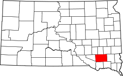
Hutchison County[1] ist ein County im Bundesstaat South Dakota der Vereinigten Staaten von Amerika.
Inhaltsverzeichnis
Geographie
Das County hat eine Fläche von 2109 Quadratkilometern; davon sind 4 Quadratkilometer (0,19 Prozent) Wasserflächen. Er wird in 23 Townships eingeteilt: Capital, Clayton, Cross Plains, Fair, Foster, German, Grandview, Hassel, Kaylor, Kuim, Liberty, Mittown, Molan, Oak Hollow, Pleasant, Sharon, Silver Lake, Starr, Susquehanna, Sweet, Valley, Wittenberg und Wolf Creek.
Bevölkerungsentwicklung
Historische Einwohnerzahlen Census Einwohner ± in % 1900 11.897 — 1910 12.319 4 % 1920 13.475 9 % 1930 13.904 3 % 1940 12.668 -9 % 1950 11.423 -10 % 1960 11.085 -3 % 1970 10.379 -6 % 1980 9350 -10 % 1990 8262 -10 % 2000 8075 -2 % 2010 7343 -9 % 1900–1990[2] 2000[3]
Städte und Gemeinden
Städte (cities)
- Freeman
- Menno
- Parkston
- Tripp
Gemeinden (towns)
- Dimock
- Olivet
- Kaylor
- Milltown
Einzelnachweise
- ↑ Hutchinson County im Geographic Names Information System des United States Geological Survey. Abgerufen am 22. Februar 2011
- ↑ Auszug aus Census.gov. Abgerufen am 28. Februar 2011
- ↑ Auszug aus factfinder.census.gov Abgerufen am 28. Februar 2011

Liste der Countys in South Dakota
Aurora | Beadle | Bennett | Bon Homme | Brookings | Brown | Brule | Buffalo | Butte | Campbell | Charles Mix | Clark | Clay | Codington | Corson | Custer | Davison | Day | Deuel | Dewey | Douglas | Edmunds | Fall River | Faulk | Grant | Gregory | Haakon | Hamlin | Hand | Hanson | Harding | Hughes | Hutchinson | Hyde | Jackson | Jerauld | Jones | Kingsbury | Lake | Lawrence | Lincoln | Lyman | Marshall | McCook | McPherson | Meade | Mellette | Miner | Minnehaha | Moody | Pennington | Perkins | Potter | Roberts | Sanborn | Shannon | Spink | Stanley | Sully | Todd | Tripp | Turner | Union | Walworth | Yankton | Ziebach
Wikimedia Foundation.
Schlagen Sie auch in anderen Wörterbüchern nach:
Hutchinson County, South Dakota — Infobox U.S. County county = Hutchinson County state = South Dakota founded year = founded date = seat wl = Olivet largest city wl = area total sq mi = 814 area total km2 = 2109 area land sq mi =813 area land km2 = 2105 area water sq mi = 2 area… … Wikipedia
National Register of Historic Places listings in Hutchinson County, South Dakota — Location of Hutchinson County in South Dakota This is a list of the National Register of Historic Places listings in Hutchinson County, South Dakota. This is intended to be a complete list of the properties on the National Register of Historic… … Wikipedia
McCook County, South Dakota — Location in the state of South Dakota … Wikipedia
Douglas County, South Dakota — Douglas County Courthouse in Armour, South Dakota … Wikipedia
Davison County, South Dakota — Location in the state of South Dakota … Wikipedia
Minnehaha County (South Dakota) — Verwaltung US Bundesstaat: South Dakota Verwaltungssitz: Sioux Falls Adresse des Verwaltungssitzes: Gründung … Deutsch Wikipedia
Ziebach County (South Dakota) — Verwaltung US Bundesstaat: South Dakota Verwaltungssitz: Dupree Adresse des Verwaltungssitzes: Gründung … Deutsch Wikipedia
Brown County, South Dakota — Infobox U.S. County county = Brown County state = South Dakota founded = 1881 [ Legislative Manual, South Dakota, 2005, p. 596] | seat = Aberdeen | area total sq mi =1731 area water sq mi =18 area percentage = 1.05% census yr = 2000 pop = 35460… … Wikipedia
Turner County, South Dakota — Infobox U.S. County county = Turner County state = South Dakota founded year = founded date = seat wl = Parker largest city wl = area total sq mi = 617 area total km2 = 1599 area land sq mi = 617 area land km2 = 1598 area water sq mi = 1 area… … Wikipedia
Hanson County, South Dakota — Infobox U.S. County county = Hanson County state = South Dakota founded year = founded date = seat wl = Alexandria largest city wl = area total sq mi = 436 area total km2 = 1128 area land sq mi =435 area land km2 = 1126 area water sq mi = 1 area… … Wikipedia
Hutchinson County (South Dakota)


18+
© Academic, 2000-2024
- Kontaktieren Sie uns: Unterstützung, Werbung
Wörterbücher Export, schritte mit PHP, Joomla, Drupal, WordPress, MODx.