- Todd County (Minnesota)
-
Verwaltung US-Bundesstaat: Minnesota Verwaltungssitz: Long Prairie Adresse des
Verwaltungssitzes:County Courthouse
221 1st Avenue South
Long Prairie, MN 56347-1347Gründung: 20. Februar 1855 Gebildet aus: Cass County Vorwahl: 001 320 Demographie Einwohner: 24.895 (2010) Bevölkerungsdichte: 10,2 Einwohner/km² Geographie Fläche gesamt: 2.536 km² Wasserfläche: 97 km² Karte 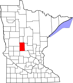
Website: www.co.todd.mn.us Das Todd County[2] ist ein County im US-amerikanischen Bundesstaat Minnesota. Bei der Volkszählung im Jahr 2010 hatte das County 24.895 Einwohner und eine Bevölkerungsdichte von 10,2 Einwohnern pro Quadratkilometer. Der Verwaltungssitz (County Seat) ist Long Prairie.
Inhaltsverzeichnis
Geografie
Das County liegt etwas westlich des geografischen Zentrums von Minnesota und hat eine Fläche von 2536 Quadratkilometern, wovon 97 Quadratkilometer Wasserfläche sind. Es grenzt an folgende Countys:
Otter Tail County Wadena County Cass County Douglas County 
Morrison County Stearns County Geschichte
 Todd
Todd
Das Todd County wurde am 20. Februar 1855 aus Teilen des Cass County gebildet. Benannt ist es nach John Blair Smith Todd (1814-1872), einem General der US Army und späteren Mitglied des Kongresses.
Demografische Daten
Historische Einwohnerzahlen Census Einwohner ± in % 1860 430 — 1870 2036 400 % 1880 6133 200 % 1890 12.930 100 % 1900 22.214 70 % 1910 23.407 5 % 1920 26.059 10 % 1930 26.170 0,4 % 1940 27.438 5 % 1950 25.420 -7 % 1960 23.119 -9 % 1970 22.114 -4 % 1980 24.991 10 % 1990 23.363 -7 % 2000 24.426 5 % 2010 24.895 2 % Vor 1900[3] 1900–1990[4] 2000[5] 2010[6]  Alterspyramide des Todd County (2000)
Nach der Volkszählung im Jahr 2000 lebten im Todd County 24.426 Menschen in 9.342 Haushalten und 6.511 Familien. Die Bevölkerungsdichte betrug 10 Einwohner pro Quadratkilometer. Ethnisch betrachtet setzte sich die Bevölkerung zusammen aus 97,54 Prozent Weißen, 0,11 Prozent Afroamerikanern, 0,48 Prozent amerikanischen Ureinwohnern, 0,31 Prozent Asiaten, 0,01 Prozent Bewohnern aus dem pazifischen Inselraum und 0,72 Prozent aus anderen ethnischen Gruppen; 0,82 Prozent stammten von zwei oder mehr Ethnien ab. 1,90 Prozent der Bevölkerung waren spanischer oder lateinamerikanischer Abstammung, die verschiedenen der genannten Gruppen angehörten.
Von den 9.342 Haushalten hatten 31,8 Prozent Kinder unter 18 Jahren, die bei ihnen lebten. 59,8 Prozent davon waren verheiratete, zusammenlebende Paare. 6,1 Prozent waren alleinerziehende Mütter und 30,3 Prozent waren keine Familien. 26,3 Prozent waren Singlehaushalte und in 13,0 Prozent der Haushalte lebten alleinstehende Menschen im Alter von 65 Jahren oder darüber. Die Durchschnittshaushaltsgröße lag bei 2,58 Personen, die durchschnittliche Familiengröße bei 3,14 Personen.
27,4 Prozent der Bevölkerung waren unter 18 Jahre alt. 8,1 Prozent waren zwischen 18 und 24, 24,7 Prozent zwischen 25 und 44, 23,8 Prozent zwischen 45 und 64 und 16,1 Prozent waren älter als 65 Jahre. Das Durchschnittsalter betrug 38 Jahre. Auf 100 weibliche kamen statistisch 101,8 männliche Personen. Auf 100 Frauen im Alter von 18 Jahren oder darüber kamen 102 Männer.
Das jährliche Durchschnittseinkommen eines Haushalts betrug 32.281 USD und das Durchschnittseinkommen einer Familie betrug 39.920 USD. Männer hatten ein Durchschnittseinkommen von 28.630 USD, Frauen 20.287 USD. Das Pro - Kopf - Einkommen betrug 15.658 USD. 9,6 Prozent der Familien und 12,9 Prozent der Einwohner lebten unterhalb der Armutsgrenze.[7]
Städte und Gemeinden
- Bertha
- Browerville
- Burtrum
- Clarissa
- Eagle Bend
- Grey Eagle
- Hewitt
- Long Prairie
- Osakis1
- Staples2
- West Union
1 - teilweise im Douglas County
2 - teilweise im Wadena CountyEinzelnachweise
- ↑ Auszug aus dem National Register of Historic Places. Abgerufen am 13. März 2011
- ↑ GNIS-ID: 659521. Abgerufen am 22. Februar 2011 (englisch).
- ↑ U.S. Census Bureau - Census of Population and Housing Abgerufen am 15. März 2011
- ↑ Auszug aus Census.gov. Abgerufen am 18. Februar 2011
- ↑ Auszug aus factfinder.census.gov Abgerufen am 18. Februar 2011
- ↑ United States Census 2010 Abgerufen am 6. August 2011
- ↑ Todd County, Minnesota Datenblatt mit den Ergebnissen der Volkszählung im Jahre 2000 bei factfinder.census.gov
Weblinks
-
 Commons: Todd County, Minnesota – Sammlung von Bildern, Videos und Audiodateien
 - Offizielle Webseite
- www.city-data.com - Todd County

Liste der Countys in Minnesota
Aitkin | Anoka | Becker | Beltrami | Benton | Big Stone | Blue Earth | Brown | Carlton | Carver | Cass | Chippewa | Chisago | Clay | Clearwater | Cook | Cottonwood | Crow Wing | Dakota | Dodge | Douglas | Faribault | Fillmore | Freeborn | Goodhue | Grant | Hennepin | Houston | Hubbard | Isanti | Itasca | Jackson | Kanabec | Kandiyohi | Kittson | Koochiching | Lac qui Parle | Lake | Lake of the Woods | Le Sueur | Lincoln | Lyon | Mahnomen | Marshall | Martin | McLeod | Meeker | Mille Lacs | Morrison | Mower | Murray | Nicollet | Nobles | Norman | Olmsted | Otter Tail | Pennington | Pine | Pipestone | Polk | Pope | Ramsey | Red Lake | Redwood | Renville | Rice | Rock | Roseau | Scott | Sherburne | Sibley | St. Louis | Stearns | Steele | Stevens | Swift | Todd | Traverse | Wabasha | Wadena | Waseca | Washington | Watonwan | Wilkin | Winona | Wright | Yellow Medicine
Wikimedia Foundation.
Schlagen Sie auch in anderen Wörterbüchern nach:
Todd County, Minnesota — Infobox U.S. County county = Todd County state = Minnesota founded year = 1856 [http://www.house.leg.state.mn.us/hinfo/govseries/No34.htm] founded date = February 20 seat wl = Long Prairie largest city wl = Staples area total sq mi = 979 area… … Wikipedia
National Register of Historic Places listings in Todd County, Minnesota — Location of Todd County in Minnesota This is a list of the National Register of Historic Places listings in Todd County, Minnesota. This is intended to be a complete list of the properties and districts on the National Register of Historic Places … Wikipedia
Gordon Township, Todd County, Minnesota — Gordon Township, Minnesota Township … Wikipedia
Moran Township, Todd County, Minnesota — Moran Township, Minnesota Township … Wikipedia
Ward Township, Todd County, Minnesota — Infobox Settlement official name = Ward Township, Minnesota settlement type = Township nickname = motto = imagesize = image caption = image |pushpin pushpin label position =left pushpin map caption =Location within the state of Minnesota pushpin… … Wikipedia
Bartlett Township, Todd County, Minnesota — Infobox Settlement official name = Bartlett Township, Minnesota settlement type = Township nickname = motto = imagesize = image caption = image |pushpin pushpin label position =left pushpin map caption =Location within the state of Minnesota… … Wikipedia
Bertha Township, Todd County, Minnesota — Infobox Settlement official name = Bertha Township, Minnesota settlement type = Township nickname = motto = imagesize = image caption = image |pushpin pushpin label position =left pushpin map caption =Location within the state of Minnesota… … Wikipedia
Burleene Township, Todd County, Minnesota — Infobox Settlement official name = Burleene Township, Minnesota settlement type = Township nickname = motto = imagesize = image caption = image |pushpin pushpin label position =left pushpin map caption =Location within the state of Minnesota… … Wikipedia
Burnhamville Township, Todd County, Minnesota — Infobox Settlement official name = Burnhamville Township, Minnesota settlement type = Township nickname = motto = imagesize = image caption = image |pushpin pushpin label position =left pushpin map caption =Location within the state of Minnesota… … Wikipedia
Eagle Valley Township, Todd County, Minnesota — Infobox Settlement official name = Eagle Valley Township, Minnesota settlement type = Township nickname = motto = imagesize = image caption = image |pushpin pushpin label position =left pushpin map caption =Location within the state of Minnesota… … Wikipedia
Todd County (Minnesota)


18+
© Academic, 2000-2024
- Kontaktieren Sie uns: Unterstützung, Werbung
Wörterbücher Export, schritte mit PHP, Joomla, Drupal, WordPress, MODx.